|
|
 The Quad County Amateur Radio Club will operate Field Day June 25-26, 2016, at the Clearfield County Fairground Community Building, yes we’ve been there before. Operating hours are scheduled to be from 2:00 PM Saturday to 2:00 PM Sunday, antennas have to be installed after the VE exam session. All amateur radio operators are welcome as well as the general public. Since the public as well as a number of Clearfield County officials and TV stations have been invited, as Club secretary, I ask that members please wear their Club shirts if possible. Thank you – in advance. The Quad County Amateur Radio Club will operate Field Day June 25-26, 2016, at the Clearfield County Fairground Community Building, yes we’ve been there before. Operating hours are scheduled to be from 2:00 PM Saturday to 2:00 PM Sunday, antennas have to be installed after the VE exam session. All amateur radio operators are welcome as well as the general public. Since the public as well as a number of Clearfield County officials and TV stations have been invited, as Club secretary, I ask that members please wear their Club shirts if possible. Thank you – in advance.
Volunteer examiners are reminded that the exam session is scheduled for June 25, 2016 at 11:00 AM. 
Operations are scheduled to start 2:00 PM, Saturday June 25, continuing through the night, with the hopes of taking advantage of any changing propagation characteristics. There is to be a Get On The Air (GOTA) station activated. The GOTA station will give new hams and those not even licensed, the opportunity to experience operating the HF bands under the supervision of a licensed amateur radio operator.

Location Coordinate information: 41°01.840 N 78°26.540 W.
Follow the route depicted by orange arrows, on the map, after you turn off Rte. 322.
You can also try the inserted interactive map to zoom and obtain directions. You can use the satellite view on the small map to compare the orange arrow map to the right.
If you operate APRS, there will be an object beacon to help you locate the Field Day site.
Please consider what will make Field Day comfortable for you, like in the real deal you will be responsible for your own comfort and personal operating conveniences such as chairs, clipboards, pens, pencils, paper. flashlights, etc. – remember to mark your property -. The main equipment will be provided, such as transceivers and antennas. I do not recall that the building is handicapped accessible. If you have a spare HF radio or antenna to bring, all the better as a just in case but only 2 will be on the air plus the GOTA station. Additionally if possible, please bring along some type of food to share.
Plans are in motion to have breakfast Sunday morning and some picnic style food for later times.
To help with the items and food for Field Day, please down load the 2 page checklist and email the Club secretary (secretary@qcarc.org) as to the items that you will supply. I’ll try to keep all the updates current on the download list. If you have anything to add, please email your input to the Club secretary.
Amateurs who are attending the QCARC Field Day, please advise the FD Coordinator by email at secretary@qcarc.org . This info is for overall planning purposes.

Although we have recent memories of snow, the summer heat really is on the way. All too many times we hear of children or pets left in a vehicle during hot summer days, sometimes with a heartbreaking ending. There are days when the temperature may seem rather low but with the sun shining through the vehicle windows, the vehicle becomes a greenhouse and the interior can heat up quickly to dangerously high levels.
View more information on this serious topic that can effect everyone at http://www.nws.noaa.gov/om/heat/index.shtml


 The Quad-County Amateur Radio Club is a WRN Ambassador “Weather-Ready Nation Ambassador™ and the Weather-Ready Nation Ambassador™ logo are trademarks of the U.S. Department of Commerce, National Oceanic and Atmospheric Administration, used with permission.”
Sometimes we peer out the window and the sky looks ominous then the wind picks up and possibly it begins to rain or hail. What may happen next can be a matter of protecting our life and property, a good reason to understand the difference between Watches and Warnings. Being prepared is a relatively simple matter, there are several good methods to personally become involved that will help yourself, your family and friends. The National Weather Service SkyWarn Spotter program is a great way to become actively involved and you do not have to be a weather background! A more passive manner may be purchasing a NOAA Weather Radio that will sound an alert when various forms of weather effect your locale. Cell phone are also a good method as many have an alert function built in as well as the availability of weather apps that can be configured to match your needs.
If you are having a problem setting up your system whether it is a NOAA Weather Radio radio or cell phone app, you can obtain help through the Quad County Amateur Radio Club, A Weather Ready Nation Ambassador. Check the announcement panel at the top of the home page for meeting dates and times.
 
The Quad-County Amateur Radio Club is a WRN Ambassador “Weather-Ready Nation Ambassador™ and the Weather-Ready Nation Ambassador™ logo are trademarks of the U.S. Department of Commerce, National Oceanic and Atmospheric Administration, used with permission.”
Already this Spring has proven that we should be prepared for some of our wildest weather! One of the best aids in keeping abreast of developing weather issues is the NOAA Weather Radio system. Having a radio at home provides an advantage to be aware of upcoming severe weather. Some of the later models of amateur radio transceivers have the NOAA frequencies programed from the factory. For the latest NOAA weather radio operational information that may effect your area and what frequencies cover your area, check out the web site at http://www.nws.noaa.gov/nwr/ .
 Remember that saying, “Turn Around Don’t Drown”. There is more to that than just the rhyming of the saying, it really is life saving information! Ignoring that life saving information not only effects the people who decide to cross a flooded area but also the emergency responders whose lives are needlessly placed in jeopardy when they get involved in a rescue of someone that fails to heed the warning. Remember that saying, “Turn Around Don’t Drown”. There is more to that than just the rhyming of the saying, it really is life saving information! Ignoring that life saving information not only effects the people who decide to cross a flooded area but also the emergency responders whose lives are needlessly placed in jeopardy when they get involved in a rescue of someone that fails to heed the warning.
The Quad-County Amateur Radio Club is a WRN Ambassador “Weather-Ready Nation Ambassador™ and the Weather-Ready Nation Ambassador™ logo are trademarks of the U.S. Department of Commerce, National Oceanic and Atmospheric Administration, used with permission.”
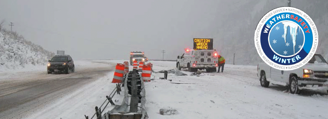
I expect that many of us have witnessed a scene very similar to the above photo. In our immediate area it is a natural event to have severe winter weather that impacts driving conditions, sometimes to the extent that we really should not be on the road. Often just postponing travel for an hour or two may enable road crews to treat the roads and give the chemicals time to take effect on the snow and ice to provide a safer traveling environment.
If you have to travel, be prepared. First off be sure you are aware of what you are getting into with severe winter weather driving. Be sure your vehicle is ready to go with a full tank of fuel and appropriate tires in good condition. Consider some additional items such as a small shovel, sand or traction mats, chains for times it gets really bad and even a very good blanket such as wool or a Mylar reflective emergency blanket. Remember to keep the cell phone charged too. Common sense helps but too often it is not so common!
Many amateur radio operators who travel have an additional resource at hand that will help with gaining a little more information about the weather. That resource can be the 2 meter transceiver which may have the capability to receive the NOAA Weather Radio announcements. Some transceivers even have a feature that will activate an alert when the NOAA radio station broadcasts their severe weather alert. Another useful service often provided through APRS digi-peaters are text alerts about road conditions that may relate to road closures due to various issues such as traffic accidents. Also some repeaters transmit bulletins relative adverse weather and road conditions.
For much more information that may make your winter and 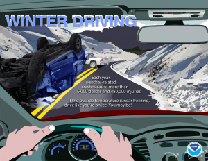
your travel safer check out the link
http://www.nws.noaa.gov/om/winter/index.shtml
The Quad-County Amateur Radio Club is a WRN Ambassador “Weather-Ready Nation Ambassador™ and the Weather-Ready Nation Ambassador™ logo are trademarks of the U.S. Department of Commerce, National Oceanic and Atmospheric Administration, used with permission.”
This year the SkyWarn™ Recognition Day will be Sunday December 5. This special event started in 1999 by the National Weather Service and the American Radio Relay Le ague to recognize the contributions of amateur radio operators during SkyWarn™ events. ague to recognize the contributions of amateur radio operators during SkyWarn™ events.
Operations are December 5 from 0000Z – 2400Z. This is not a contest but an operating event that encourages operators to contact as many amateur stations as possible, whether they are on the air at a Weather Service Office or otherwise. Stations exchange call signs, signal reports, locations, and a one or two-word description of the weather at their respective locations. Bands that are activated for this event are typically 80 meters through 70 centimeters using all modes, including digital.
Updated details are available on the National Weather Service SkyWarn™ Recognition Day web site http://www.wrh.noaa.gov/mtr/hamradio/
It’s that time again when Mother Nature will soon shift into another season that some folks love and some hate! Winter can bring some rather enjoyable times but also some treacherous times. It is the treacherous times, with winter storms, that we have to be ready to deal with in order to make those times as safe as possible.
Winter weather issues highlighted during the week can be found by clicking the weekday tabs at: http://www.weather.gov/ctp/WinterWeatherAwarenessWeek
Be sure that your NOAA Weather Radio is operating properly and has fresh batteries in the event the electric goes out.
You can find some addition information about the NOAA Weather Radios at: http://www.nws.noaa.gov/nwr/index.php
Also remember to check out the 2015 Fall edition of the SkyWarn Spotter Newsletter at: http://www.weather.gov/media/ctp/Spotter%20Newsletters/Fall2015.pdf
The 2015 – 2016 winter outlook can be found at: https://www.climate.gov/news-features/videos/2015-16-winter-outlook
Last but not least, another site for winter weather information can be found at: http://www.nws.noaa.gov/om/winter/index.shtml
The Quad-County Amateur Radio Club is a WRN Ambassador “Weather-Ready Nation Ambassador™ and the Weather-Ready Nation Ambassador™ logo are trademarks of the U.S. Department of Commerce,
National Oceanic and Atmospheric Administration, used with permission.”
Even though hurricanes typically do not significantly impact our area, there are times when they do and it may be worthwhile to keep aware of hurricane developments.
Amateur radio is one way to keep aware with the Hurricane Watch Net on 14.325 MHz. There is also a Hurricane Watch Net web site that has quite a bit of information available. Along with keeping informed, be ready with fully charged hand-helds, a full tank of fuel for your vehicle, if you’re lucky to be high enough where flooding risk is minimal consider the possibility that you may be out of electric service for a while.
There is also more information to avail yourself at the National Weather Service/NOAA websites to be able to keep updated with the latest conditions and forecasts for hurricanes.
The following sites will help you stay informed:
http://www.weather.gov/
http://www.nhc.noaa.gov/
http://water.weather.gov/ahps/
Just remember “Turn round Don’t Drown“!
The Quad-County Amateur Radio Club is a WRN Ambassador “Weather-Ready Nation Ambassador™ and the Weather-Ready Nation Ambassador™ logo are trademarks of the U.S. Department of Commerce, National Oceanic and Atmospheric Administration, used with permission.”
From ARRL:
[UPDATED 2015-09-30 @ 1940 UTC] The National Hurricane Center (NHC) has made it official: It’s Hurricane Joaquin, a Category 1 storm. But the NHC said that Joaquin is gaining strength and “could become a major hurricane during the next couple of days.” The Hurricane Watch Net (HWN) activated at 1500 UTC today (September 30) on 14.325 MHz (after nightfall, the net will convene on 7.268 MHz) to gather observer reports. WX4NHC at the NHC is not active at this time. Currently packing maximum sustained winds of 85 MPH, Hurricane Joaquin was about 190 miles east-northeast of the central Bahamas as of 1800 UTC. A hurricane warning is in effect for the central Bahamas, including Cat Island, the Exumas, Long Island, Rum Cay, and San Salvador.
“Due to the close proximity to land, whether or not this storm makes landfall in the Bahamas, the Hurricane Watch Net will be active until the storm is no longer a threat in this region,” said HWN Manager Bobby Graves, KB5HAV. “Everyone along the US East Coast should keep a close eye on this system. The current forecast brings Joaquin near the New England area by late Sunday or early Monday.”
During HWN activation, the net control station will request measured/observed ground-truth data from stations in the affected area. The HWN also remains available to provide back-up communication to official agencies, such as emergency operations centers and Red Cross officials in the affected area. The net also will gather and report to FEMA officials in the NHC any information on significant damage. Stations should not check into the net unless specifically requested to do so.
The NHC reported at 1800 UTC that Joaquin was moving toward the southwest at nearly 6 MPH. “A general motion toward the west-southwest or southwest is expected to continue through tonight,” the NHC said. “A turn toward the northwest and a decrease in forward speed are forecast on Thursday or Thursday night.The center of Joaquin is expected to move near or over portions of the central Bahamas tonight and Thursday.”
According to the NHC, Hurricane conditions are expected to reach portions of the Central Bahamas by Thursday morning. “Winds are expected to reach tropical storm strength in the warning area tonight, making outside preparations difficult or dangerous. Preparations to protect life and property should be rushed to completion,” the NHC said.
Dangerous storm surges are possible, and Joaquin is expected to produce 5 to 10 inches of rain, with isolated maximum amounts of 15 inches possible over San Salvador and Rum Cay through Friday morning.
The NHC said swells generated by Joaquin will affect portions of the Bahamas over the next few days and will start affecting portions of Florida’s eastern coast and the US southeast coast by Friday. “These swells are likely to cause life-threatening surf and rip current conditions,” the NHC predicted.
“We’re monitoring the situation and the forecasts regularly. Like most, we’re waiting to see which way the storm will go,” ARRL Emergency Preparedness Manager Mike Corey, KI1U, told the ARRL Field Organization leadership in the areas that could be affected by Joaquin. “ARRL Headquarters will be in touch with our National VOAD partners, FEMA, and NHC as things develop.”
Visit the HWNwebsite for the latest information on this storm and HWN activation plans.
Even with the bright colors and cool temperatures, Fall can also hold some rather hazardous weather too. Be prepared for the hazards that can occur during this time of year as many of us are winding down from a hectic summer.
 Click for detailed information on what various Fall weather hazards can occur and how you can prepare for a safe Fall.
The Quad-County Amateur Radio Club is a WRN Ambassador “Weather-Ready Nation Ambassador™ and the Weather-Ready Nation Ambassador™ logo are trademarks of the U.S. Department of Commerce, National Oceanic and Atmospheric Administration, used with permission.”
The current American Radio Relay League Special Service Club renewal certificate was received at the August meeting of the QCARC. Members can be proud of the Club’s continuing involvement in Public Service, Training, VE Exams, Mentoring, etc. that enable the Club to continue to maintain the Special Service Club designation.
What is Special Service Club?
To quote the ARRL –
“A club that exists to go above and beyond for their communities and for Amateur Radio is what defines a Special Service Club (SSC). They are the leaders in their Amateur Radio communities who provide active training classes, publicity programs and actively pursue technical projects and operating activities.”

We have been invited to the Super 322 Drive-In Car Show again this year to set up a station. Set up time 9:00 AM, Sunday August 16. Weather forecast looks good bring your sunscreen and a lot of water to keep hydrated. I understand there are food vendors on site too.
Location is east of Clearfield on the North side of Route 322, on your left approximately 1 mile east of the traffic light in front of Gio’s (intersection Rte 322 & Rte. 970). West bound – on your right approximately 1.7 miles west of the Bigler traffic light at the Bigler Mini Mart (intersection Rte. 322 and Allport Cutoff road). Talk-in: 147.315, N3QC repeater.
Here is the car show web site for more information such as the car and truck categories.
http://www.super322drive-in.com/upcomingevents.htm
|
|