|
|

The National Weather Service Flood Safety Awareness Week Begins March 27. Considering we experience flooding in our area rather often, it is likely worth your time to check out the National Weather Service flood safety week web page at http://www.weather.gov/ctp/floodSafetyWeek
The week starts out with information on the continuing effort to modernize the hydrologic information that enables the general public to be aware of water levels in bodies of water in their areas. An interactive, real time hydrologic map of PA.
Toward the bottom of Monday’s page are a couple downloads in .pdf format that may be of interest.
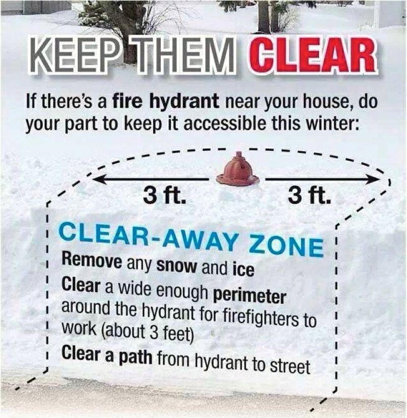
One of my favorite topics is the “Turn Around Don’t Drown” information that is available, that EVERYONE should follow. If people do not follow the simple phrase they are risking not only their own life and those who may be in the vehicle with them but also the lives of the rescue responders. The “Turn Around Don’t Drown” campaign is highlighted Tuesday.
The balance of the week includes; the causes and severity of floods, flood insurance and flood safety.
Please take some time to refresh yourself of flooding issues and the safety points that everyone should be aware of.

I know this is not directly related to amateur radio but it is directly related to neighborhood safety.
It may even be directly related to your safety!

If there is anything true about our world it is change! The changes on the NWS pages has been moved to April, as the information states.:
“Effective April 4, 2017, NWS will implement the next version of the forecast pages. Highlights will include a standardized look and feel, a mobile-ready landing page, and a completely new architecture with a modernized API. Please review the Service Change Notice for complete details.”
As part of our continued effort to modernize weather.gov, the National Weather Service (NWS) is upgrading our point forecast, zone forecast, and product pages. Once these changes go live on March 7, all existing bookmarks to forecast.weather.gov will change. Links to a forecast page will display an error message that includes a URL to the new location. You will need to update your bookmarks to continue to access our forecasts quickly after the upgrade. After March 7, the new URL can also be found by searching for your location from forecast.weather.gov or www.weather.gov. These changes will not impact office pages located at www.weather.gov
If you run an automated process to get NWS data from forecast.weather.gov, you will need to switch to the new developer API by March 7. Specifications for the new API can be found here.
The primary focus of the upgrade is to make the forecast pages more reliable during weather events, but there are some new benefits of new forecast pages that include:
-
Addition of 7-day hourly forecast information to the point forecast page
-
A new mobile-friendly landing and graphical/tabular forecast page
-
Low-bandwidth optimization for all pages, on a partial roll-out at launch
-
Option to automatically detect your location on a mobile device
-
A new widget mode that allows you to customize the information on the point forecast
We overhauled the architecture of our application platform to provide a more stable and consistent service to meet the demand of severe weather events. The platform also introduces a modernized API that will make it easier for web developers to create high-quality applications and services to share NWS data. The updated web site now provides a complete mobile-friendly experience with optimizations for low bandwidth and customized weather widgets. We also have new data centers located in College Park, MD, and Boulder, CO, to provide 100% backup capability for the operational data used within the forecast process.
We look forward to providing you with useful and timely information using our improved connectivity and new design.
For more details, please read our Service Change Notice.
Questions can be sent to kolly.mars@noaa.gov


As we’ve seen this winter, the weather can change rather quickly. Especially when traveling, we need to be prepared for those extremes during our winter travels. One of the biggest issues this winter has been the occurrence of white-outs. Often times these winter squalls materialized so fast there is no time to react and the ensuing results can be catastrophic, as we have seen in our locale.
Preparing for winter travel includes both the folks in the vehicle as well as the vehicle. Click on the Getting Traction graphic for more information about preparing yourself and your vehicle for travel during the winter. You can never be too safe!
The week of November 7 – 11, 2016 is the National Weather Service Winter Weather Awareness Week in Pennsylvania. Currently it sure does not seem like winter is coming but rest assured it is! Some of the indicators seem to predict a harsh winter. I have a boatload of acorns on the ground which is supposed to be indicative of a bad winter but I recall at least once before when there was a plentiful crop of acorns and the winter was rather mild.
To keep up on the information that the National Weather Service will be posting during the week, be sure to visit the web page daily at
http://www.weather.gov/ctp/WinterWeatherAwarenessWeek
With hurricane Matthew’s track that effected Haiti, Jamaica and Cuba, it is probable there will also be issues in the Bahamas, Florida and points north along the coast as well as inland from the coast. The following frequencies have been posted, by Sean Kutzo of the ARRL, as frequencies that may be used by relief agencies and would be advisable to avoid for general contacts. Check http://www.arrl.org/home for information and links to current amateur radio activities. For information on the hurricane the National Weather Service http://www.nhc.noaa.gov/ is a good place to view maps and forecasts. along the coast as well as inland from the coast. The following frequencies have been posted, by Sean Kutzo of the ARRL, as frequencies that may be used by relief agencies and would be advisable to avoid for general contacts. Check http://www.arrl.org/home for information and links to current amateur radio activities. For information on the hurricane the National Weather Service http://www.nhc.noaa.gov/ is a good place to view maps and forecasts.
Remember that 7.268 MHz & 14.325 MHz are used for the Hurricane Watch Net http://www.hwn.org/ and given the nature of the communications please refrain from operating nearby to prevent any interference with the relief efforts. Please do not check into the emergency or weather nets unless you have something relevant to contribute.
14.325	7.080
14.265     7.045
7.268       3.740
7.120       3.720
7.110
A surprising statistic in the U.S.A. for 2016, as of August 21 there have been 27 fatalities due to lightning, which is the total for 2015! It is difficult to definitively determine why so many people have been killed by lightning strikes so far this year. It could be that the word is not getting out. It could be that people are not hearing the information about the seriousness of lightning. It could be that people are just plain ignoring the fact that lightning is a major factor in deaths, especially during outdoor activities. Personally I believe it is the last possibility.
 Lightning strikes the Empire State Building and other buildings Please heed the warnings especially about moving indoors when you first hear lightning. I have first-hand experience when it comes to seeing the “bolt out the blue”. When the “bolt out of the blue” struck, I believe the storm was about 10 miles away. By the way, myself nor the other fellow who I was talking to heard thunder! Fortunately we were in his house but only about eighty feet from the tree that was struck. That was one lesson learned but everyone does not have the luck of a safe experience of a close strike to talk about.
Click on the photo of lightning striking the building for and interesting list of “Lightning Myths and Facts”.
Check out the National weather Service web site about the lightning strike statistics at:
http://www.lightningsafety.noaa.gov/fatalities.shtml
Also check out the web site on ways lightning strikes people at:
http://www.lightningsafety.noaa.gov/struck.shtml
The Quad County Amateur Radio Club is a Weather-Ready Nation Ambassador
“Weather-Ready Nation Ambassador™ and the Weather-Ready Nation Ambassador™ logo
are trademarks of the U.S. Department of Commerce, National Oceanic and Atmospheric Administration, used with permission.”
 The countywide burn ban that was enacted at the the July 19 Clearfield County PA, Commissioners meeting, was lifted as of 8/16/2016. The countywide burn ban that was enacted at the the July 19 Clearfield County PA, Commissioners meeting, was lifted as of 8/16/2016.
For the entire article relating to the burn ban see the GantDaily.com website http://gantdaily.com/2016/08/16/breaking-clearfield-county-lifts-burn-ban/
Jefferson County PA has also lifted their burn ban.
Although we have recent memories of snow, the summer heat really is on the way. All too many times we hear of children or pets left in a vehicle during hot summer days, sometimes with a heartbreaking ending. There are days when the temperature may seem rather low but with the sun shining through the vehicle windows, the vehicle becomes a greenhouse and the interior can heat up quickly to dangerously high levels.
View more information on this serious topic that can effect everyone at http://www.nws.noaa.gov/om/heat/index.shtml


 The Quad-County Amateur Radio Club is a WRN Ambassador “Weather-Ready Nation Ambassador™ and the Weather-Ready Nation Ambassador™ logo are trademarks of the U.S. Department of Commerce, National Oceanic and Atmospheric Administration, used with permission.”
Sometimes we peer out the window and the sky looks ominous then the wind picks up and possibly it begins to rain or hail. What may happen next can be a matter of protecting our life and property, a good reason to understand the difference between Watches and Warnings. Being prepared is a relatively simple matter, there are several good methods to personally become involved that will help yourself, your family and friends. The National Weather Service SkyWarn Spotter program is a great way to become actively involved and you do not have to be a weather background! A more passive manner may be purchasing a NOAA Weather Radio that will sound an alert when various forms of weather effect your locale. Cell phone are also a good method as many have an alert function built in as well as the availability of weather apps that can be configured to match your needs.
If you are having a problem setting up your system whether it is a NOAA Weather Radio radio or cell phone app, you can obtain help through the Quad County Amateur Radio Club, A Weather Ready Nation Ambassador. Check the announcement panel at the top of the home page for meeting dates and times.
 
The Quad-County Amateur Radio Club is a WRN Ambassador “Weather-Ready Nation Ambassador™ and the Weather-Ready Nation Ambassador™ logo are trademarks of the U.S. Department of Commerce, National Oceanic and Atmospheric Administration, used with permission.”
Already this Spring has proven that we should be prepared for some of our wildest weather! One of the best aids in keeping abreast of developing weather issues is the NOAA Weather Radio system. Having a radio at home provides an advantage to be aware of upcoming severe weather. Some of the later models of amateur radio transceivers have the NOAA frequencies programed from the factory. For the latest NOAA weather radio operational information that may effect your area and what frequencies cover your area, check out the web site at http://www.nws.noaa.gov/nwr/ .
 Remember that saying, “Turn Around Don’t Drown”. There is more to that than just the rhyming of the saying, it really is life saving information! Ignoring that life saving information not only effects the people who decide to cross a flooded area but also the emergency responders whose lives are needlessly placed in jeopardy when they get involved in a rescue of someone that fails to heed the warning. Remember that saying, “Turn Around Don’t Drown”. There is more to that than just the rhyming of the saying, it really is life saving information! Ignoring that life saving information not only effects the people who decide to cross a flooded area but also the emergency responders whose lives are needlessly placed in jeopardy when they get involved in a rescue of someone that fails to heed the warning.
The Quad-County Amateur Radio Club is a WRN Ambassador “Weather-Ready Nation Ambassador™ and the Weather-Ready Nation Ambassador™ logo are trademarks of the U.S. Department of Commerce, National Oceanic and Atmospheric Administration, used with permission.”
Lately many of us have heard stations from rather distant areas on the 147.315 repeater. It is interesting to hear those stations that we normally do not hear but often it is just due to a weather phenomenon called and inversion. I expect that some amateurs sit back and wonder just what is this inversion thing that some offer as an explanation for the unusually distant stations heard and some stations that we can even carry on a QSO with. Sometimes the stations seem as though they are just audible for enough time to hear a call sign but other times long enough for a typical QSO. Then there are times that you may not even be able to hear or access your local repeater and again you will hear folks offer the explanation as an inversion as well.
Consider the simplified diagram of an inversion below. Note that typically as you increase elevation the temperature lowers but with an inversion the opposite happens! You can see the yellow area depicting the inversion, which actually ends up acting as a boundary layer that can either attenuate the signal to and from the repeater or at times signal attenuation can occur to the extent of both blocking the repeater from hearing your transmitted signal and from you hearing the repeater’s transmitted signals. This occurrence can lead one to believe the repeater is off the air. I recall years ago there were trips made to the repeater site when we could not use the repeater, only to find the repeater operating. All due to an inversion. Sometimes the inversion layer is well above what the diagram depicts too, leading to other stations that you will be able to talk with that you would not ordinarily be able. There is another term used for this phenomenon which is called ducting that enables more distant than typical communications to occur, especially on VHF as well as UHF.
Inversions, ducting, tropo and what ever other titles the phenomenon of having radio signals reflected and refracted is an interesting and vast topic of which you can read up on. Look for propagation of radio signals either on the Internet or the ARRL Handbook for Radio Communications, what was previously called the Radio Amateur’s Handbook.

|
|